|
New Caledonia
Islands in the western Pacific. Consists of a large island called Grande Terre, and a small set of islands called the Loyalty Islands (also known as New Hebrides).
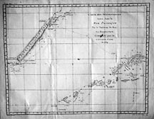 |
Cook, 1778
Chart of New Caledonia, with Grande Terre on the left and the Loyalty Islands on the right. The map also shows the travels of Captain Cook through the island chain.
|
 |
Bellin, 1780
From a slightly later atlas published by Bellin, this is basically the same map as the Cook map above. (But is a better image to view!) |
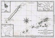 |
Gaspard, 1787
A slightly later map than the ones above, this chart includes insets (clockwise from upper left) Norfolk Island, Havre de Balard, Port Sandwich, and Port Resolution. |
|